|
Return to map
Rankin WMA and Dutch BottomsBirding Seasons: Spring A Summer A Fall A+ Winter B
Site Description and Habitats Rankin WMA, 1,255 acres, is composed of islands and floodplains that are submerged during the warm season impoundment of Douglas Reservoir. In late summer and early fall, the area consists of mudflats, open shallows, and both inundated and dry floodplain forest. The area is approximately 65% open, treeless floodplain; 25% black willow/buttonbush/cottonwoods; and 10% mid to late mixed floodplain forest. Virtually the entire area is under 1'-15' of water from mid-May through July. Maximum ground exposure lasts roughly from mid-October until late March. The amount and proportion of habitats vary with the reservoir level. Lake elevation ranges from about 995' to about 950'. Migratory shorebird habitat is most extensive from 988 to 978'; no mudflats are found above 992'. TVA has been holding water high way too long into the summer and suitable mudflats are often not available until August, sometimes late August. TWRA recently (2014) acquired the majority of the uplands and fields on the peninsula that is on the west side of the train tracks. The area is comprised mostly of mature upland hardwoods and some old fields. The site has not been birded since it has only recently been announced, but the area holds great potential for passerine migrants and is worth exploring (and reporting via eBird!). Dutch Bottoms is the floodplain west of Hwy 25E and south of the large bridge over the river (Walters Bridge). Bird species of interest Spring and Fall Migration: Shorebirds are the main draw with over 30 species found here over the years: Spotted, Solitary, Western, Least, Semipalmated, Stilt, Pectoral, Baird's, White-rumped, and Buff-breasted Sandpipers, Semipalmated Plover, with American Golden and Black-belliedpossible but rare, American Avocet (rare), Short-billed and Long-billed Dowitcher, Dunlin, Sanderling (rare but regular), Lesser and Greater Yellowlegs, among others. In late summer 2011, 25 species of shorebird were recorded here in ONE day! Summer: Osprey, Prothonotary Warbler, Wood Duck, Chimney Swift, Warbling Vireo, Eastern Kingbird, and Blue-gray Gnatcatcher. Cliff Swallows nest in a large colony under the Rankin Bridge and are present from mid-April through mid-August. Winter: Hermit Thrush, Ruby-crowned and Golden-crowned Kinglets, gulls, and sparrows including White-crowned, Swamp, White-throated, and Savannah. Year-Round: Bald Eagle, Killdeer Rarities Seen at this Site: Ruff, White Ibis (rare but annual), Ross's Goose, Red Knot, Red-necked Phalarope, Red Phalarope, Hudsonian and Marbled Godwit, Least Bittern, Glossy Ibis, Reddish Egret (2nd state record), Piping Plover, Least Tern, Common Raven Species list via eBird Hotspot Explorer - Dutch Bottoms Submit your data to eBird here
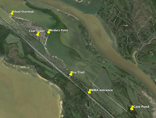
Detailed directions for birding Rankin WMA An alternate route to Rankin Bottoms is through Newport. Take I-40 Exit 432B - US 25E/70 towards Newport. After 2.6 miles, turn left (north) at a stoplight onto US 25E-N. After 0.8 miles, turn right (east) onto Industrial Road. Drive 5.4 miles to the intersection with Rankin Hill Road. Rankin Bridge (see below) is immediately to your right, and the intersection of Rankin Hill Road and Hill Road is about 0.3 miles to your left. If approaching from the northeast on I-81, take Exit 8 and head south on US 25E for 6.5 miles to the bridge over Dutch Bottoms. Then follow the directions in the first paragraph of this section. Once you cross ther train tracks, you pass a sign for the entance to the WMA. There is one parking lot that doesn't directly overlook the water, but there is a poison ivy covered trail that leads through the narrow woods. Continue down the gravel road, at one point paralleling the train tracks, to open views of the lake/mud flats. You can drive through the old coal tipple to additional viewing areas. When the lake is low, there is a gravel road that goes off the high ground into the flats. You can drive this, when dry and safe, to get better access and views. Stay in your car to minimize flushing the birds. You can get pretty close to shorebirds in your car here. TWRA recently (2014) acquired the majority of the uplands and fields on the peninsula that is on the west side of the train tracks. There is a small parking area off Brown's Ferry Rd. The gate will alwas be closed, but the poorly maintained gravel road is open for foot traffic. The road gives access to views of the Ten Islands area (west side of the peninsula) and nice upland hardwoods. Brown's Ferry Rd is a shady gravel road that is about 0.2 miles before you cross the train tracks as you go towards Rankin WMA. Be sure to check out the area at the Rankin Bridge which is just 0.25 miles to the south of the intersection of Rankin Hill Rd and Hill Rd (which takes you to Rankin WMA). In spring and summer, hundreds of pairs of Cliff Swallows nest under the bridge and Osprey nest on the adjacent abandoned bridge. There is a very wide shoulder on the bridge and a boat ramp on the east side of the bridge.
Map of Rankin Bottoms and birding spots (thanks to Michael Sledjeski) Shoal Overlook - view of the mudbar developing along the French Broad riverbank; accessed by driving under the Coal Tower ("tipple")
Dutch Bottoms is often a more reliable place to find Sanderling in fall. In addition, Common, Forster's, and Caspian Terns can be found in August and September. Various waterfowl may be present at times, along with Ring-billed Gulls, and occasionally Laughing and Franklin's Gulls. Peregrine Falcons and Bald Eagles also pass by regularly and keep the birds stirred up. Lat-Long (GPS) coordinates: Fees and Hours Hazards Facilities Contact Info for other sites
|